Skip to content

Posts tagged ‘trekking’

some trekking pictures

Everest Base Camp

Lunch (most days) – p.b. and honey on a chapati

Everest

Trying to survive a 14 hour snowstorm

Climbing up Cho La

view from our guesthouse in gokyo

YAK!!!!!

The beautiful Cho Oyu (over 8000m!)

The beautiful Gokyo valley (on our way down to Namche)

These pictures are thanks to Katherine (as my camera battery died early in our trek) – thanks K!!!

Life  continues to be good here in Kathmandu — from early morning runs to Korean donut shops with wifi to $5 massages to making plans (not ready to make them concrete….)

take care friends — much love — aurora

Trekking – final installment

Way back when (before we were tired and hungry for sure) we decided to fly to Lukla and then walk to Shivalaya on the way out (and then take a bus back to Kathmandu).  Most people fly both ways.  Some people choose to walk in via Shivalaya – as a good way to get in shape and acclimate themselves.  Very few people choose to walk out via Shivalaya.  In fact, we saw no one else going our way….

The trek itself doesn’t go through valleys, it goes over them. Pretty much every day, you go up and down at least once, if not twice.  There are several (4 or so) high passes — high for the middle hills – one is around 3500m.  It is not an easy trek.  It is definitely a good trek to get prepared for the Everest region.  Maybe not so good when you are finishing….

In all seriousness, it was beautiful — lush green river valleys, high passes, villages, stupas, chortens — all the ingredients of life out in that region of Nepal.  We were seeing it all.  Unlike the Everest region, people live and work and farm and scratch out their lives in this area.  (well, people work in the Everest region – but most of the guesthouses exist because of the trekkers – not because people actually live there!)

As I mentioned, this time of year is Dasain – so we passed a lot of people headed home to be with their families.  One of the important parts of Dasain is the sacrifice.  Just so happened that we were trekking on sacrifice day.  At one point, Katherine turns to me:  ‘oh, god. They are going to sacrifice something.’  we stopped some ways away from the crowd of people, but could hear the swift chop.  As we walked up, we could see them bleeding out the goat and washing off the goat head.

At another house we passed, a kid excitedly ran out to greet us with a freshly skinned goat head in hand, moving the mouth for us.

oh, sacrifice day.

The trek is suppose to end in Shivalaya were you can catch a bus to Kathmandu — takes about 10-12 hours, sometimes more depending on the roads.  We really wanted to catch a bus there.  we were tired (did i mention that already?).  we were hungry (did i mention that either?).  wanted to stop walking.  But we kept hearing word that buses were not going to Shivalaya – instead we would have to walk another half day to Jiri to catch the bus.  Yet, every now and then, someone would raise our hopes and tell us — no, no — you can catch a bus in Shivalaya.

So – long story short – we had people making calls and connections for us every which way (the brother of our guesthouse owner in Kinja owned a guesthouse in Shivalaya and he would look into it for us – but we could have lunch at his sister’s guesthouse in Duerali – and if the bus didn’t work out – we could go to Jiri because here was another connection…..)

No buses in Shivalaya.  Not because of the road.  Nope.  The bus was there.  The driver w as there.  But it was the festival.  So – onto Jiri we went.  6 days after we left Namche we were in Jiri, done walking with a backpack – ready to eat up some miles on a bus.

Though I was ready for it to be done while I was doing it, it was pretty amazing to catch a glimpse of rural life in the Nepal countryside.  To see how people really live out there.  And the green countryside was amazing  – especially after being up in the mountains for so long.  The other really cool thing about the trek is that this is the way the first Everest (and other Himalayan explorers) expeditions went – before you could fly into Lukla – you had to walk in this way.  So, it was pretty cool to get that piece of history as well.

I will post pictures when I get them — though we did not take a whole lot on our way out…  both our batteries were dead and we were just about ready to be done.

But there you have it — there is the story of our 22 days trekking!  whew….  that took awhile!

take care — lots of other fun stories coming your way soon!

love – AK

Trekking – part deux

Ok, so to finish the trek…..

After the clouds rolled in on Kala Patar, we headed down as we knew we had another pass, Cho La, the next day to head to.  We said goodbye to Scott as he was headed back to Namche and we headed to Dzonglha, the town right before the pass which sits at the foot of Cholatse (pretty amazing views).  The whole way there it was raining and totally overcast.  In fact, a pretty miserable day to be trekking!  On our way there, we ran into Ben – as he was pretty much doing the same trek as we were doing.  He gave us some books (i kept running out of reading material!!!) and told us about the passes we were about to go over.  We would have loved to hang out and talk more — but the weather was miserable so we headed off.

We reached Dzonglha (population – two trekking houses) just as the weather cleared a bit for views of Cholatse and Ama Dablam.  But soon it clouded over again and started to snow!!!  We went to bed that night thinking it wouldn’t be a problem and we would head over the pass in the morning…..

Which was not the case.

It went on to snow for the next 14+ hours….. we spent the ENTIRE day sitting in the sunroom of the guesthouse – waiting for the snow to stop.  waiting for our next meal.  waiting for them to start the dung heater (it was damn cold up there).  We played farkle.  we read.  we  played gin rummy.  we drank milk tea.  we stared into space.  we were intrigued by the other group snowbound – 3 germans who did NOT talk to us at all (one of which spent the entire day laying down on the bench in the sunroom covered by a comforter).  We listened to avalanches coming off the mountains around us.  Needless to say, it was a LONG day!!!!

We weren’t sure what we were going to do — should we head over the next day?  At one point, there was word that someone had come over the pass in the storm – though we didn’t talk to them since they were at the other guesthouse.  But the guide came over and there was lots of talk in Nepali about what had happened and gesturing at us since we were hoping to go over the pass the next day.  We weren’t sure if they wanted us to hire the guy or what….  but we figured we could make it ourselves (not really knowing the path or or how much snow or any of those important details!).

The next morning we woke to amazingly clear skies, 8-12 (or more) inches of new snow (down low) and brilliant mountains in every direction!  It was beautiful!  So, off we went.  For a while it went well…..  we could find of see the indentation of the trail.  Until we couldn’t….  At one point, the two of us were standing in the middle of this valley – knowing we had to go up, but which way….  all of a sudden – we heard a sharp whistle from down in the valley – there was the guide who had come over the pass the previous day – he was headed home and willing to show us the way!

We encouraged him to go at his own pace (mine was way slower!) and we would just follow in his tracks – but he stayed with us (or rather, waited for us) all day.  And it was a long day…. we were postholing.  Sometimes sinking into drifts of snow that was mid-thigh depth.  The sun was so damn bright and hot (after complaining all those days that we had no sun….).  There were avalanches all around us (or at least on the mountains around us).  We were the first people going over the pass — and though neither Katherine or I was breaking trail, it was still incredibly hard work.

The pass itself was beautiful – we reached it once we crossed a small glacier (at which point we were really glad we were following the guide – and by guide, I mean he was a dude who worked at a guesthouse that was on the otherside of the pass!).  We could see mountains all around us, though it did start to cloud up in the distance (so no everest!).  Then we started down — which we thought – oh, good, going down can’t be as hard…. wrong again.

Plunge stepping into what is technically a scree field and postholing, slipping and sliding is not actually fun, in case you were wondering!  It was brutal.  Then we had to go back up a hill that had not just one false summit, but 3!  oh, it was rough.  and long.  and I got slower and slower (buddy asked if I wanted him to take my pack – I must have looked that drained….  )  Finally, 8+ hours later – we made it to Tagnag (the collection of guesthouses just over the pass).  We had intended to go further to Gokyo (another 2+ hours) but we opted for food, milk tea and sleep instead!

The next day we were back on track and headed to Gokyo – crossing the Ngozumpa Glacier – which extends down from Cho Oyu.  It was a huge glacier crossing with some sketch moments of rockfall – since it was yet another beautiful day.  But, within two hours we were in the beautiful village of Gokyo – which is set on one of the sacred lakes and surrounded by mountains.  Absolutely stunning.  Since we got there early in the day, we picked a guesthouse down by the lake and we were able to do laundry and dry ourselves and our clothes out in the sun.  But Renjo La, our third pass awaited us.

We thought we would head out the next day – but no one had been over yet.  And following our experience on Cho La, we were not looking forward to being the first over.   Plus, we woke up the next morning to clouds over the pass – so we figured we wait out another day to make our decision.  At this point, we were tired, hungry (it was hard to eat enough to not feel hungry all the time!), and Katherine had come down with a cold.  A rest day would not do us harm.  But, we were still undecided about what to do.

Finally, 3 people came over the pass, dropping into Gokyo.  They reported a story similar to ours – postholing, slipping, tough navigating.  At that – we made up our minds.  Head down the Gokyo valley to Namche.  There are plenty of times when we have to go a certain way to get out of the woods (or have to follow kids for 8 hours in the rain through the notch).  But here, we didn’t have to do anything — we could just head down the valley and head out.  So we did.  Peace out Renjo La.

The next day we hightailed it to Namche.  We were pretty excited to get there — veggie burgers, coffee, apple turnovers, chocolate cake, apple strudel, cheese.  We were hungry and we spent about 12 hours there eating (did I mention that it was hard to get enough calories and to feel full while we were trekking?  by that point in the trekking, i felt like i could eat every two hours and then, maybe, feel full).

But, unfortunately, we still weren’t done.  We still had 4 or 5 more days to go…..

To be continued…..

3 Passes — wait, make that 2

Ok — our trek.

Well — as you know, we finally made it to Lukla.  Once there, Katherine, Ben and I (we somehow lost Scott in the shuffle) started making our way to Namche.  Everyone pretty much has to go through Namche, no matter what trek they are doing.  Even though you technically start in Lukla (or in Shivalaya if you are trekking in instead of flying in — but more on that later), it really seems that the trek starts in Namche.  Lukla is quite a scene – porters and guides asking you once you arrive if you need them, gear shops galore and lots of ‘products’ everywhere.  There is a ‘starbucks’ there as well — not a real starbucks, but it looks very similar (inside and out) though the logo has mountain instead of whatever the real logo is. And the coffee wasn’t half bad!  It took us a day and a half to get to Namche — we got there on the second morning.  Imagine, hiking up in the hills when all of a sudden you come around a corner and there is a small village!  It was kind of a surprise — tons of guesthouses, internet cafes, bakeries, bars, gear shops and a market on saturdays!  I could see how people could get stuck there for awhile (plus the apple turnover and coffee we had there was awesome!).  It is also kind of a fun scene because there are people there from all over the world — well, ok, mostly French, German, some Israelis, Canadians, Australians and a few Americans.
We were in Namche for the earthquake — which was fairly exciting since we did not really know what was going on.  It was kind of scary since our guesthouse was kind of on stilts (Namche is set into the side of a very steep river valley — meaning that it is nestled into the hillside facing a huge valley that has cliffs and mountains far on the other side – pretty beautiful).  At first we weren’t sure if it was wind or mud or…. an earthquake!  But we all ran outside and then it was calm….  it was strange being some place where you don’t speak the language and something like that happens — you realize that life could change pretty drastically in a matter of seconds…..  Funny enough, we had found Scott earlier that day and Ben, Scott, Katherine and I were all hanging out talking when the earthquake happened!  A plane adventure, now an earthquake adventure….   seemed like it was time to hit the trail!
The next day — we all did just that and went our separate ways.  Katherine and I were headed to Chhukung where we would prepare to go over our first pass, Kongma La. It took us a few days to get there — which were spent traveling through landscape that could have been in Lord of the Rings (only made more so by the rain and clouds).  It is tough there because you can only trek so much in one day – you don’t want to go too high and risk altitude sickness.  So, that meant for some long days in the tea houses for us.  The tea houses mostly had sunrooms which were pleasant enough to sit in, though the rooms tended to be drab, damp, cold places.  We spent a lot of time drinking milk tea waiting for our next meal in the sun rooms.  At least in Chhukung there were some good day hikes – Island Peak base camp and Chhukung Ri (which was actually our highest point at 5546m)– a mountain that should have had amazing views — that is if it was sunny out!!!!  which it was not….  though we did get some views….  Did I mention that Chhukung is at the base of Ama Dablam?

it finally started getting pretty clear in the mornings!

Island Peak Base Camp with a huge amazing glacial pool (that is growing due to global climate change)

Ama Dablam

 Finally, it was time for us to go over our first pass – Kongma La which was at 5535 meters.  It was a beautiful morning, though unfortunately it did not stay that way all day…  that is also the day my camera battery died….

on top of Chhukung Ri – our high point of the trip

Early morning on the way up

beautiful morning

on top of the pass

So – we make it over Kongma La — it was clear on the way up, but clouded over by the time we reached the pass — you can see in the picture above that there was this awesome lake up there — but no real summits in view.

Coming over the pass, we dropped down to the Khombu side — meaning we had to cross over the Khombu glacier into Lobuche – which is where we met up with the Everest Base Camp trek folks.  We were so use to quiet – most people do not go over Kongma La — so the wave of people going to EBC was kind of crazy (and it wasn’t even busy season yet!).  Crossing the glacier was kind of cool — it was just so huge – and the moraines on either side were huge rock piles we had to cross.  It wasn’t dangerous where we were – but it was cool to hear the rockfall into the glacial pools that were forming where the ice was melting.

Once we dropped into Lobuche we could go to the actual base camp and Kala Pattar – which is a summit that people climb in order to see Everest.  We did go to both places.  Actual base camp isn’t all that exciting — though it is cool to see a place I have read so much about.  There were two parties there preparing to climb — though it is a heavy snow year (we ran into another group that had tried to go up Lobuche Peak and were stymied from all the snow).  It was pretty cool to see the Khombu Icefall – which I have also read so much about.  But you cannot see the summit of Everest from base camp – so it is just a mass of tents, really.

Kala Pattar was beautiful on the way up.  We started up at 4:30 in the morning – hoping for clear skies.  It was clear on the way up — but just about the time we reached the summit – it clouded over….  of course.  I did get a glimpse of Everest and there will be pictures coming.  We ran into Scott up there and he had some good pictures and Katherine has some as well.

I can’t say we were sad to leave that scene — it was definitely kind of crazy — everyone trying to get to base camp — which is strange because there are just so many amazing other places to go up there.

Ok — i will continue the rest of the trek story later.  Enough for now!  I will leave you in suspense on the rest of the story!

Take care – love – AK

Just getting there….

It was quite an adventure just getting to Lukla to start our trek….

As you know, our first attempt did not work out well for us….  we were at the airport for about 8 hours before we were sent home to try again the next day.  So, the next day, we showed up – ready for a long wait.  But no sooner had we sat down and prepared ourselves to buy an overly sugared shot of coffee that you can buy at the airport (which is not quite coffee but more colored water that is WAY sweet) – than the ticket guy came by and waved us on for the plane!  Yes — we are going to Lukla!

Aboard we got on the twin otter (sits maybe 20?) and away we go.  It is a beautiful flight – over wooded valleys towards the mountains.  We can just barely make out the mountains although it was pretty clouded over.  About 15 minutes in, we notice that the plane is taking a nose dive into the mountains (on purpose) and  we seem to be headed right for the ground!  Since Katherine and I are seated right up front, we can see the mountains and then all of a sudden a short grassy runway – and bam, we are on the ground.  The 6 of us or so on the flight who are not nepali are slightly confused – is this Lukla?  When all of a sudden, the pilot turns to us all and says – this is not Lukla.  The Lukla aiport has closed.  We are in Phalpu.

Of course, that means nothing to any of us – other than we are not in Lukla.  We all sort of look at each other and then people make a move to get off the plane.  There is a lot of confusion outside of the plane and a lot of standing around.  Lots of rumors are going around (stemming mostly from the fact that we do not speak nepali and even the nepali seem confused!).  We are not sure if we are getting to Lukla that day or….

so — there we stood for awhile (like 4 hours) just waiting for word.  at first it sounded like we would be going later that day.  then it sounded like we would have a choice to whether we wanted to go back to Kathmandu or stay the night in Phalpu.  One german woman decides to leave with her guide.  They are going to walk to Lukla – we hear it is a 3 day trek (later confirmed by Katherine and I when we do it – but that is getting ahead of the story….)

ben, scott, katherine and I playing farkle to pass the time

At this point, we have made friends with the two other trekkers – Ben from Australia and Scott from the states.  We tell stories, drink tea that some one has brought down (he brought down a cup of milk tea for all of us waiting there) and play farkle.

When it is decided that we are staying in Phalpu for the night, the pilot and crew head back to Kathmandu – katherine has the pilot promise to come back and get us in the morning.  We all (meaning everyone who was on the plane) head up and find a guest house — who were not prepared for 20 guests!  Ben, Scott, Katherine and I go find food and go for a walk – as we are all stuck in this tiny town for the night.

The next morning as we were getting ready to order breakfast we got word that the plane was going to be arriving so we skipped breakfast and hurried down to the airfield.  We excitedly watched a plane fly in, circle over a few times and then….. fly way….  There was all sorts of conversations, Nepalis are talking to each other, we of course have no idea what is going on…..

Then word comes to us that there was no one in the tower.  The guy is late for work.  So, people go off searching for him while the rest of us just sit there… hungry, wondering when we will get to lukla….

Finally, they find him.  He took a different path to work and got lost.  you know….  as it happens sometimes.

anyway— a few hours later, another plane arrived, picked us up and 15 minutes later we were in Lukla having breakfast and drinking coffee (at starbucks!).  No problem.

There is of course lots and lots more to tell….  i will be getting to it over the next few days.  Kat and I are going to go explore the city (and drink coffee and eat donuts and walk as little as possible!).  Good to be back and good to be in touch!  much love!

all is well

this is a quick post.

we are still trekking – we have done 2 of the 3 passes — just one more to do.  we were going to go this morning but the cold, wind, snow and possible earth quake damage kept us in our bags (since it was 34 degrees in our room).  but our location in gokyo could not be more beautiful.

we have survived a surprise landing in phalpu (b/c the lukla airport closed on our way there), survived the earthquake, survived a 14 hour snowstorm, made it up two 5400 + meter passes (first people up one after the snowstorm — which kicked our asses), and now just one more pass before we start the trek to jiri to catch a bus to kathmandu.

we are both tired –‘ ready to be done trekking and ready to eat something else other than dal bhat and chapatis.

ok.  talk to you later.  miss and love you all.

and other happenings….

there was great news about my school this past week or so when Governor Patrick visited:

http://www.masslive.com/news/index.ssf/2011/09/patrick_makes_first_of_two_sto.

Glad to see Renaissance getting the good word it deserves!

Also, tomorrow, we fly to Lukla to start the three passes trek – which will take us a little over 20 days – so we will be out of touch again for awhile…. we are hoping we get some good views and some sweet tea and probably more dal bhat than we can wish for (though I do love the tibetan bread and momos!)

here is a NYT article about the trek:

http://travel.nytimes.com/2011/04/10/travel/10explorer-everest.html?scp=1&sq=three%20passes%20trek%20everest&st=cse

but then, from there, who knows what I will be doing….  the plan will evolve I am sure.  I have had moments of definitely missing home and my community, but glad to be pushing myself out here!

Annapurna (the long version)

Alright….  the afternoon rains have started here in Kathmandu, time for me to post about the Annapurna trek.

Just getting there was an adventure!  We took a public bus to the bus stand – we were so proud of ourselves for figuring it out….  though others on the bus were not so thrilled with our big packs!  We had to take ring road (which goes around the city of Kathmandu) to the bus stand.  Well….  it wasn’t so much a bus stand – but various vendors on the side of a very busy road – with lots of people seeing opportunity when they saw us!  We had lots of offers for taxis, buses, and probably other items that we were unaware of!

Finally, we got a bus to Besi Sahar where our trek would start.  Our bus, a ‘micro’ was basically a 15 passenger van, but it can fit up to 21 people (as evidenced on our ride out).  our packs went up top and away went. People got in along the way, people got out, loud Nepali music blared, we passed trucks and buses on blind curves, we bumped over potholes, kids puked.  Lots of good times. and then 6 long, hot, dusty hours later we arrived in Besi Sahar – ready to start our trek the next morning.

The trek starts in what are called the Middle Hills, lush, green hills that are filled with villages, terraced rice paddies, and waterfalls.  Oh, and leeches….  yes, we are trekking at the end of the monsoon season, so there are leeches — because everything is wet and hot and humid and we were walking in puddles and sometimes streams….  we realized it on day two when Katherine had blook soaking through her pants on her calf.  I hesitantly pulled up my pant legs and … EEK!  No leech to be seen, but plenty of dried blood on my leg!  then, later, when I pulled off my socks — three more leech attachs — though we have no idea where the leeches went — probably just took their fill and lept off!  ewwwww…..

Have to say, we were happy to get out of the middle hills — though it was pretty — it was HOT and HUMID and sticky and we were ready for some mountain time…. The higher we went, the cooler it got and the air did get some what drier…. (did I mention that we were trekking at the end of the monsoon?!)

Also, the higher we went, the further north we went, the more buddhist it became.  Every little village we came to had prayer wheels and chortens (or stupas) at the entrance.  Each spin of the prayer wheel sends your prayers to the gods.

All the while we were hiking at this point, we were folowling a river up through a steep canyon – with water falls thundering down every couple of hundred feet.  Finally, we started to climb out of the river valley and up onto a ridge.  We found a nice guest house up on top of the ridge – it seemed like it would have a great view — but of course, everything was hidden in clouds.

[side note — you might be wondering where we stayed each night.  The Annapurna circuit is famous for a lot of reasons – the views being one of them, of course, but it is also a great trek because there are tea houses all along the way that you can stay at.  Katherine and I would pick a place where we wanted to stay when we got to a village – and we had our choice since it is before the trekking season really starts.  Each guest house has nice enough rooms and you eat at the restaurant downstairs.  We usually ate dal bhat – but there were other options though we thought the dal bhat (lentls) was a safer option since that is the local food!)  Here is a picture of Katherine finding us a guest house before we got into town:

If we didn’t do our research ahead of time, people would be calling out to us left and right and it ended up being really confusing.  But, for the most part, all of our guest houses were really nice.]

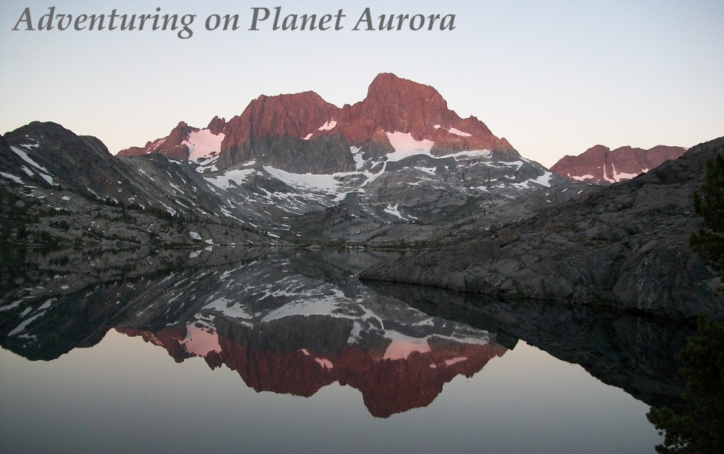
Ok — back to the guest house on top of the ridge….  Well, the guest house was at about 3670m – which meant that the air was getting thinner.  Neither of us slept really well – from the air or from the excitement of being up high – not sure!  But, in any case — morning came and….. THERE WERE THE MOUNTAINS!!!!  our first real view of them in the morning light!!!!

It was pretty amazing up there….  we all just spent awhile staring and taking pictures (not knowing when this would happen again – which, as it turned out to be, not another clear day!)

Our days became increasingly shorter the higher we got — the reason for this is that you just cannot go too high and not expect to get sick from acute mountain sickness.  This is all well and good, however, it lead to some rather boring days….  3 days in a row we hiked for roughly 2-4 hours before we came to  our guest house….  and since we are early risers, this meant that we sometimes got in before lunch — which meant a whole lot of sitting around – reading, journaling, playing farkle.  It often rained in the afternoon, as well, which limited the number of hikes we could (wanted) to do.  But eventually – it was pass day.  The day we hiked up to Thorung La – the high pass before you descend down to the other side (which meant that the trek was over for us – since we were just doing the first half of the trek).

The hike up to the pass was not too bad – neither of us were really feeling the altitude too bad – though we did take it slow on our approach.  It took us about 3 hours to get to the pass and then another 3 hours of straight down to reach the ‘end’ of the trek (though more about that in a moment).

yep — that reads 5416m (close to 18,000 feet!!) which I think is the highest I have ever been.  It was pretty sweet up there — though there were NO views….  which was too bad.  but it was cool to be up there….  then, as I said, we headed down down down to Muktinath — which is very dry.  It is in an area called Mustang which is not all that far from Tibet (and reminded me a lot of Ladakh).  After we got to Muktinath, showered, ate a lot of food, visited the Muktinath religious center (it is a place of pilgrimages – see the photo of some of the 108 waterspouts), the next  day we made the long dusty walk to Jomson where we bought a plane ticket to fly to Pokarh in order to come back to Kathmandu.

All in all, the trek was pretty great — though they are building a road on the east side (the one on the west side is complete) and that was sometimes tough to take (all the road walking and road construction) — but all in all a great trek.

Some other highlights:

more mountains….

Suspension bridges (they were all over and pretty amazing and sometimes scary!):

lots of mani stones (I think that is what they are called — that are engraved and sitting on chortens or prayer wheel ‘stations’ as you enter or leave town):

and I will leave you with a picture of katherine and I at the pass:

of course there are gazillion moe pictures but it takes forever to upload them…..  i will figure something out!

Back from Annapurna

we made it back from Annapurna today. The trek was great – everything from high passes to rice paddies to snow covered mountains in the distance to leeches! And lots of dal bhat!

Hopefully a long post tomorrow with pictures….